Tagged digitization

Final rendering of 3D model of Bethel Seminary.
2

Creating Dynamic Undergraduate Learning Laboratories through Collaboration Between Archives, Libraries, and Digital Humanities

Abstract

In an environment of rapid change in higher education in which institutions strive to lure prospective students with unique curricula, there is a growing need to provide innovative pedagogical experiences for students through collaborations among archives, libraries, and digital humanities. Three colleagues at a small Liberal Arts university—a digital librarian, a historian-archivist, and a historian-digital humanist—planned an integrated set of assignments and projects in an “Introduction to Digital Humanities” course that introduced students to archival management and digitization of archival material. This article demonstrates how we developed this signature course and curriculum on a limited budget in the context of a liberal arts university, and illuminate how it capitalized on relationships forged among the archives, the library, the history department and the digital humanities program. We first describe our collaborative workflow, and how we involve undergraduate student-workers in these efforts. Next, we provide a detailed lesson plan for an Introduction to Digital Humanities course that integrates traditional archival materials, in this case photographs and blueprints of campus structures, into a digital archive. Finally, we share how our students converted these photographs and blueprints into digital 3D models via Sketchup, a powerful architectural modeling software.

Introduction

In an environment of rapid change in higher education in which institutions strive to lure prospective students with unique curricula, there is an increasing need to provide innovative pedagogical experiences for students through collaborations among libraries, archives, and digital humanities. There is also a growing body of literature—on research support for scholarship, curriculum development, collaborative publishing, and on shared values across these organizations and disciplines—about how historians, librarians, archivists, and digital humanists can forge mutually supportive relationships (Locke 2017; Middleton and York 2014; Rutner and Schonfeld 2012; Svensson 2010, para. 39; Vandgrift and Varner 2013). Kent Gerber (Digital Library Manager) Diana Magnuson, (archivist at the History Center and historian), and Charlie Goldberg (Digital Humanities coordinator and historian), are colleagues who set out to do just that at Bethel University, a small Christian Liberal Arts university in St. Paul, Minnesota. Applying insights from these literatures to the ever-evolving landscape of humanities teaching in higher education, the three planned an integrated set of assignments and projects that spanned a new “Introduction to Digital Humanities” course. “Introduction to Digital Humanities” was the first course in the new Digital Humanities major, and was designed to: engage and motivate students early in the curriculum with “hands-on, experiential, and project-based learning … where students think critically with digital methods” (Burdick et al. 2012, 134); “develop a broader set of skills … essential to students’ success in their future careers” (Karukstis and Elgren 2007, 3); and give students meaningful experiences and agency as a form of “professional scholarship” rather than placing them in a position of fulfilling “menial labor in a large-scale project” (Murphy and Smith 2017, para. 8). Our thinking about the design of this course was influenced by the pedagogical theory of Brett D. Hirsch, Paolo Freire, and Claire Bishop (Murphy and Smith 2017). Collaborative teaching always poses special challenges, but we anticipated that our diverse backgrounds and training would result in a rewarding and distinctive experience for our students.

This article will explain how we developed this signature course and curriculum in the context of a liberal arts university, and illuminate how it capitalized on relationships forged among the archives, the library, the history department and the digital humanities program. Built on the foundation of the material holdings of the History Center (Magnuson), the Digital Library (Gerber) was able to grow connections and extend the reach of these materials through an infrastructure of digital skills and collections. This combination provided a robust environment for the campus community to seek and eventually establish a Digital Humanities program, including a new major and a new faculty member (Goldberg) to develop and coordinate the program. The curriculum developed along the lines of Cordell’s four principles of how to incorporate digital humanities into the classroom, including starting small, integrating when possible, scaffolding everything, and thinking locally (2016). These relationships and principles enabled the development of a course, “Introduction to Digital Humanities,” which engages the archives, the digital library, and digital humanities domains in a mutually supportive and emergent cycle of learning and research.

Opportunities for undergraduate digital humanities scholarship and pedagogy are burgeoning, particularly at more prestigious liberal arts institutions. Occidental College in California, Dickinson College in Pennsylvania, and Hamilton College in New York all maintain well-funded centers for either Digital Liberal Arts or Digital Humanities focused on undergraduate students. There are also several noteworthy inter-institutional collaborations among liberal arts schools—COPLACDigital (comprised of more than twelve schools), the Five Colleges of Ohio (Oberlin College, Denison University, Kenyon College, Ohio Wesleyan University, and the College of Wooster), the Five Colleges Consortium in New England (Amherst, Hampshire, Mount Holyoke, and Smith Colleges, and the University of Massachusetts Amherst) and St. Olaf, Macalester, and Carleton Colleges in Minnesota have all received collaborative grants from the Andrew W. Mellon Foundation.

At schools (like our own) that lack these resources, it can sometimes feel like the unique pedagogical opportunities afforded by this support are beyond the reach of faculty and staff. Our aim here is to describe our collaborative experiences and provide other scholars with a model of how the archive can intersect with digitization efforts and undergraduate pedagogy at smaller institutions of higher education. Together, these assignments and projects produced learning outcomes related to concepts in the humanities, archival research methods, digital competencies, information literacy, and digital humanities tools and software (Association of College and Research Libraries 2016; Bryn Mawr College n.d.).

History Center

The History Center, the archives at Bethel University, contains the institutional records of the university and its founding church denomination, known as Converge (formerly the Baptist General Conference). The History Center provides stewardship of manuscript and digital materials, collects historically relevant materials, curates three-dimensional objects, offers access to special collections, assists researchers, documents the story of its institutions and supports the mission of Bethel University and Converge. The types of collections housed at the History Center include but are not limited to: institutional records of Bethel University (college and seminary); Baptist General Conference (and all its iterations) minutes and annual reports; conference and university publications; church and district records (from both active and closed churches); home and foreign mission records; Swedish Bibles and hymnals; bibliographic records on conference pastors and lay persons; photographs and other media.

The director of archives at Bethel University (Magnuson) is a part-time position created in 1998 and held by a full time faculty member in the history department. This dual appointment provides unique positioning for the faculty member to provide a bridge for students between academic and public history. Students in her classes work with a variety of primary source materials, regardless of the level of the history course. Through the faculty member’s engagement with students in the classroom, Magnuson identifies students with proclivity for detail, curiosity about archival work, and willingness to explore a variety of primary source material. Sometimes, just by working with primary sources, or hearing a description of archival work or records management, a student reacts enthusiastically to the physical and intellectual encounter: “This is so cool, where can I have more of this kind of experience?” Over and over again, the experience of encountering a primary source in its original form is at once awe inspiring and profoundly transformative for the student. It is one thing to read about one of the first professing Baptist believers in nineteenth century Sweden and the impact this life had on Swedish Baptists in America, but it is quite another kind of experience to encounter in person the artifact of his diary (Olson 1952).

Two or three students each year are invited to work with the director of archives as student archive assistants. Students with a major or minor in history are given preference in the application process. Once hired, over the course of an academic year, students are exposed to and trained in: initial stages of archival control; digital inventory projects; arrangement and description; digital metadata entry; and patron assistance. For example, our students have contributed to developing collections focusing on photographs, film, artifacts, institutional records such as catalogs, yearbooks, and student publications.

In 2009 Bethel University hired someone for the newly created position of Digital Library Manager (Gerber). Since then, both the History Center and the Digital Library have transformed into dynamic learning laboratories for our undergraduate students to experience first-hand the tools of the professions of history and digital librarianship. The now nearly decade-long partnership between the History Center and the Digital Library is characterized by lively and productive collaboration on a number of fronts. For example, students hired by the history department are trained and work with both the Director of Archives and the Digital Library Manager. Major equipment that benefits both the History Center and the Digital Library has been purchased through mutual consultation and contribution of funding, such as an overhead book scanner and 3D scanner. Monthly meetings identify and move forward projects, workflow, grant applications, institutional initiatives, web presence, and troubleshooting as the need arises. At the behest of the Director of Archives and the Digital Library Manager, two foundational committees were formed to anchor our institutional conversations about our cultural heritage: the Cultural Heritage Committee and the Digital Library Advisory Committee, respectively. These committees support the History Center and the Digital Library through institution-wide input, drawing committee members from faculty, staff, and administration. In tandem we are significantly growing the breadth, depth, and reach of our collections, not only to our Bethel community, but to the world.

The Digital Library as Infrastructure and Bridge between the Archive and the Classroom

Of the Bethel Digital Library’s twenty-six collections spanning five major themes—Bethel History, Art and Creative Works, Faculty and Student Scholarship, Natural History, and the Student Experience—the majority of the content comes from the cultural heritage materials held in the History Center. Digitization of these unique materials broadens their availability to the community for teaching and research while simultaneously preserving the originals from wear because they do not need to be handled as frequently. Regular conversation between the Digital Library Manager and the Director of the Archives developed the library and archive as an infrastructure of values, practices, and workflows enabling a deeper understanding of Bethel’s cultural holdings and a broader reach of those materials to the Bethel community and beyond (Gerber 2017; Mattern 2014). In one of his series of four seminal articles on digital humanities, Director of the HUMLab in Umea University, Patrick Svensson discusses how the research-oriented infrastructure of technology, relationships, and practices, called “cyberinfrastructure” can be built specifically for humanities teaching and research (2011). Magnuson and Gerber’s collaboration developed a cyberinfrastructure at Bethel with the scanners, software, networked computing, meetings, digital collections, and committees mentioned above. The shape and scale of these resources influences a broad range of digital humanities literacies and competencies, as Murphy and Smith point out in their introduction to the special issue of Digital Humanities Quarterly focused on undergraduate education (2017, para. 7).

Bringing student workers into this cyberinfrastructure of the Digital Library and History Center also continued this cooperation and cross-pollination of knowledge and skills, and introduced them to information literacy skills and digital competencies. The first set of concepts these students learn are aspects of the Association of College and Research Libraries Framework for Information Literacy in Higher Education. Information literacy is “the set of integrated abilities encompassing the reflective discovery of information, the understanding of how information is produced and valued, and the use of information in creating new knowledge and participating ethically in communities of learning.” Knowledge of these skills has particular potency due to the influence of Mackey and Jacobson’s (2014) concept of “metaliteracy,” which expanded on information-literacy abilities with respect to the networked digital environment, rapidly changing media, increased consumption and production of media, and critical reflection upon one’s self and the information environment (ACRL 2015, para. 5). The Framework consists of six frames, or core concepts, of information literacy, which are marked by certain knowledge practices and dispositions when a learner moves through a threshold of awareness from novice to expert. The six frames are, in alphabetical order: 1) Authority is Constructed and Contextual; 2) Information Creation as a Process; 3) Information Has Value; 4) Research as Inquiry; 5) Scholarship as Conversation; 6) Searching as Strategic Exploration.

Digital competencies, as developed at Bryn Mawr College, are a useful complement to information literacy, spanning media and disciplines, specifically focused on the digital environment, and developed within the context of a small, liberal arts college. This model of skills is organized into five focus areas and can be used as learning objectives or as descriptions of skills one already has. The five focus areas are: 1) Digital Survival Skills; 2) Digital Communication; 3) Data Management and Preservation; 4) Data Analysis and Presentation; and 5) Critical Making, Design, and Development (Bryn Mawr, n.d.).

Informed by their work in the archives with historical materials, student workers in the archive and the Digital Library are exposed to and develop skills and competencies related to the above ACRL information literacy frames and the Bryn Mawr digital competencies. They accomplish this through learning the processes of digitization, learning how to use scanning equipment and image manipulation software, writing descriptive metadata, and encoding finding aids in a version of XML called Encoded Archival Description (EAD) for public display. Going through these processes introduced students to information literacy frames of “Information Creation as a Process” and “Information has Value” as well as digital competencies like “Digital Survival Skills,” “Data Management and Preservation,” and “Data Analysis and Presentation” (Association of College and Research Libraries 2016; Bryn Mawr, n.d.). As students begin work with the Digital Library, they begin to realize the limit of their own skills and abilities with technology and recognize how they can grow their awareness and competencies with “Digital Survival Skills,” particularly in the subcategory of “metacognition and lifelong learning.” The competency of “Data Management and Preservation” included learning more sophisticated hardware like flatbed scanners and the software environment of spreadsheets. The flatbed scanner process involved scanning at a high enough resolution for the resulting image to represent the original in print or digital formats as well as enable the ability to zoom in for very close examination afforded by a digital format. Some students had not used spreadsheets before and learned how to navigate a spreadsheet and use them to organize different categories of data and store multiple records of items. Students were introduced to the domain of “Digital Analysis and Presentation” through classification methodologies and learned how to navigate a digital archive to research a topic of interest. The skills students learned from these experiences motivated them to learn more and prepared them for further study in graduate school or employment in the cultural heritage sector. This built a culture of trust, common understanding, and shared competencies between both units and set a foundation for further integration of Bethel’s cultural heritage in the classroom and the establishment of the Digital Humanities major (Bryn Mawr College n.d.).

While these competencies and literacies were building in student workers, it was necessary to integrate the learning of these concepts more broadly into the general curriculum so that more students could benefit. Some classroom opportunities emerged as a result of the digitization activities in various classes and disciplines. Students researched historical events and trends through their increased access to documents within a collection like the historical student newspaper collection for their journalism projects, engaging the frames of “Research as Inquiry” and “Searching as Strategic Exploration.” Students in a computer science course on data mining were also able to use the corpus of metadata from collections like the student newspaper, college catalogs, and faculty research as an object of study in their projects to identify trends in course offerings, changes in campus space, changes in school mascots through the years, and profiles of particular individuals in Bethel’s history. These assignments and experiences also built some familiarity with ways to engage archival material in classes other than a history class. Some of these students were excited to make these discoveries and had a heightened interest in the history of the institution, but their ability to pursue it in any depth was limited by the length of one single assignment.

In 2017, two developments in Bethel’s cyberinfrastructure improved the scope and scale for student learning anchored in these concepts: the launch of Bethel’s Makerspace in the Library and the creation of a Digital Humanities major. Bethel’s Makerspace is the result of a purposeful design discussion consisting of a cross-disciplinary group of faculty, staff, and administrators. This discussion resulted in a technology-infused space in the Library to explore innovative, creative technologies and encourage collaboration and experiential classroom experiences through the use of 3D scanners, 3D modeling and media production software, photo studio equipment, movable furniture, 3D printers, and meeting space for groups and classes. With the Digital Humanities program in place beginning in 2017, a new opportunity emerged for students to use the Makerspace as a lab to learn information-literacy concepts and digital competencies as demonstrated by other programs (Locke 2017, para. 8–49; White 2017, 399–402), and to engage more fully in the physical archive and the digital collections.

The Archive in Digital Humanities Pedagogy

Powerful technology has never been more accessible to educators, even, as we describe above, to educators at smaller schools like our own. Yet there remains the assumption that the digital humanities are best left to R1 institutions with deep pockets and deep rosters of instructors and support staff (Alexander and Frost Davis 2012; Battershill and Ross 2017, 13–24). However, there is a growing conversation and community of practice for undergraduate and liberal-arts–oriented digital humanities education, like the Liberal Arts Colleges section of the Digital Library Federation, that seeks ways for smaller institutions to thrive (Buurma and Levine 2016; Christian-Lamb and Shrout 2017; Locke 2017, para. 7). Bethel has been able to do this through incremental financial investments in technology and intentional partnerships like the efforts of the History Center and Digital Library mentioned above. In 2016–2017, Bethel designed and launched a new undergraduate Digital Humanities major informed by concepts from digital humanities pedagogy that capitalized on the existing technical and relational investments that can be available to faculty at most institutions with limited means (Brier 2012; Cordell 2016; Wosh, Moran, and Katz 2012).

We have benefited greatly by our archival holdings in the History Center. A particular challenge to incorporating digital humanities in the classroom is avoiding the technological black hole, whereby the technology used to make something becomes the focus of the thing itself, demanding the attention of both instructor and student at the expense of the humanistic subject. The archive, as an essential repository of humanistic data, can help anchor the traditional humanities at the center of digital humanities pedagogy. Here, we share an example of a lesson plan that aims to do just this—to craft an undergraduate archival project that is at once technologically sophisticated yet true to traditional humanistic values—all without the use of expensive equipment.

This project was inspired by a research trip Goldberg made to Rome as a graduate student at Syracuse University. On a day off from research, he visited Cinecittà, a large film studio just outside the city that housed the set for the 2005 HBO series Rome. The studio still maintains the set, featuring a scale replica of the ancient Roman forum, and allows visitors to traipse the grounds as part of a tour. As a Roman historian, standing in a replica of the forum was a powerful experience for Goldberg, and delivered a new sense of historical place and space that examining traditional scholarly materials—maps, plans, and written descriptions—couldn’t match.

When Goldberg arrived at Bethel in the Fall of 2016 and began designing the Digital Humanities curriculum, he looked for ways to emulate his experience abroad. Digital 3D modeling, including virtual reality applications, can provide such an immersive experience for the viewer, and holds a special value for bringing archival materials to life (Goode 2017). Working in tandem with Magnuson and Gerber, it became apparent that the History Center archive contained a treasure trove of materials pertaining to the university’s spatial past: photographs of historical groundbreaking ceremonies, architectural blueprints, and design sketches. Particularly alluring were plans and renderings for campus expansions that never panned out; such materials suggested alternative campus realities that would have fundamentally altered the contexts of how students, faculty, and staff interact with one another on a daily basis.

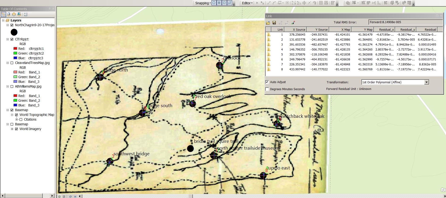
During a summer meeting in the History Center, we began to design a six-week lesson plan for Goldberg’s semester-long Introduction to Digital Humanities course. Our primary pedagogical goals were twofold: 1) to introduce students to archival digitization practices, culminating with the creation of digital records for traditional archival materials; and 2) to create immersive, experiential worlds based on the History Center’s architectural records. We determined that Trimble’s Sketchup, a 3D modeling program used by architects, interior designers, and engineers, was the best software tool for goal #2. Even more, Trimble provides 30-day trial versions of its Pro software for educators and students, long enough to cover the three weeks dedicated to 3D modeling in this assignment. They also now offer Sketchup for Web, an entirely online, cloud-based version of the software, which eliminates the need to install the software on campus or student computers, though it does lack certain key features of the Pro version.

For this assignment, students chose a building, actually built or only existing in design plans, from the campus’s present or past. They chose two photographs or other visual records of it from the History Center (such as blueprints or design illustrations), and were tasked with incorporating these as entries into the Digital Library. This aspect of the assignment was structured over three weeks, and gave students an introduction to many of the professional archival practices and digitization fundamentals described above, providing a hands-on “experiential” learning opportunity that immersed them in the fabric of our institutional history. Finally, students were to create 3D digital models of their structure using Sketchup. This final step also took three weeks.

As Digital Library manager, Gerber took the lead in the first half of the assignment. Because most students were freshmen, we assumed no previous exposure to the archival setting. We therefore took a field trip to the History Center, where Magnuson gave an overview of her work there and introduced students to basic archival practices. We then reassembled as a class to learn some basic digital competencies like how medium impacts the experience and the meaning of an archival item by comparing and contrasting physical and digital versions of the same object. Once introduced to this framework, the class focused on how any object, be it a photograph, document, or physical object, possesses a range of features unique to it and how to attach a description of it to a digital file in order to be intelligible and findable by both humans and computers. To use a nonarchival example, an action figure is made of a certain material (e.g., “plastic”), is a certain size (e.g. “8 inches tall”), made by a certain company (e.g., “Mattel”), in a certain year. This basic principle is a crucial aspect of proper digital asset management, and allowed us to introduce the concept of “metadata,” or information about an object that describes its characteristics. We stressed the importance of metadata in the archival setting and introduced our students to the Dublin Core Metadata Initiative, an international organization dedicated to maintaining a standard and best practices for describing and managing any kind of information artifact including archival material. At its heart, Dublin Core consists of fifteen common elements necessary to describe the metadata of any archival object (e.g., “Title,” “Creator,” “Subject,” “Description,” etc.). We then looked at how items catalogued in the Digital Library store this metadata and apply local standards, like the Bethel Digital Library Metadata Entry Guidelines, adapted from the Minnesota Digital Library Metadata Entry Guidelines, to determine what kind of information is needed in each element. We focused particularly on the purpose of the Title and Description elements in the Historical Photographs Collection and analyzed the quality of the entries based on how well they provided context and facilitated discovery of the item by a potential researcher. For example, the Title element for the image of Esther Sabel, a prominent woman in Bethel’s history, was used to demonstrate levels of quality seen in Table 1: Poor – “Woman,” Good – “Portrait of Esther Sabel,” Better – “Portrait of Esther Sabel, Head of Bible and Missionary Training School.” Finally, based on this scaffolding, students were given the assignment of analyzing two images in the Historical Photographs Collection with insufficient or erroneous metadata, and improving the records in this Metadata Improvement Worksheet using a shared Google Spreadsheet.

Poor Descriptive Titles Good Descriptive Titles Better Descriptive Titles
These titles lack specificity and do NOT assist users in finding materials. These are examples of basic descriptive titles. These titles provide users with more specific information and relay exactly what is in the image.
Woman Portrait of Esther Sabel Portrait of Esther Sabel, Head of Bible and Missionary Training School
Crowd of People Group of students sitting on grass Group of seven students outside signing yearbooks
Table 1. Excerpt from Bethel Digital Library Metadata Entry Guidelines.

In the second week, we gathered several folders of photographs, blueprints, and architectural renderings awaiting catalogue entry in the History Center, and had our students spend some time perusing their contents. Since the assignment was quite long at six weeks and culminated in a large finished digital work that some students found intimidating, we found that students greatly appreciated this unstructured exploration, or “tinkering” (Sayers 2011) time. These photographs provided intimate glimpses into the university’s past and unrealized future(s), and motivated our students to find out more about the students who came before them. Students then selected two images for entry into the Digital Library, and received their second assignment: tracking down the necessary metadata. Their submissions would become a publicly-available part of the Historical Photograph Collection, adding a “real-world” application incentive to this assignment. Some images were easier to provide metadata for than in others, with dates or a list of subjects written on the back. Photographs of ground-breaking ceremonies could be dated by looking up construction dates for buildings on campus. Others required reasoned speculation. Dates for difficult photographs could be estimated by the style of clothing of the people photographed, for example.

In the third week, students wrote a two- to three-page blog post synthesizing Digital Library records into a narrative of a past campus event. Some students chose to write on their dorms or the campus building they had previously studied, while others wrote on a key historical event, such as Martin Luther King Jr.’s scheduled visit to campus in the 1960s. This aspect, since it required close reading of a text or texts, was the component of the assignment most aligned with the traditional humanities, and helped alleviate some anxiety in the instructors that this digital-centered project might stray from core humanities values.

In the second half of the assignment, students created three-dimensional digital models of their campus building using Trimble’s Sketchup. Sketchup is a popular software tool with an active and enthusiastic online support community. Having access to a wide range of tutorial walkthroughs and videos greatly reduced the learning curve for acclimating both instructor and student to the software. There are also several guides and tutorials written specifically for those in the digital humanities community, which provide helpful tips for applying it to the humanities classroom. In particular, Goldberg benefited from the step-by-step guide for creating 3D models from historical photographs written by Hannah Jacobs at Duke University’s Wired! Lab, as well as Kaelin Jewell’s use of Sketchup to bring medieval building plans to life (Jewell 2017). We have made Goldberg’s intro and advanced tutorials available online. The fourth week was devoted to installing Sketchup on student computers and learning the basics. Students with experience playing video games tended to get up to speed faster than others, as the software’s simulated three-dimensional environment can be disorienting at first. Students, and instructors, should be encouraged to simply search Google if there is a particular process they are struggling with, since there are many helpful tutorials on YouTube.

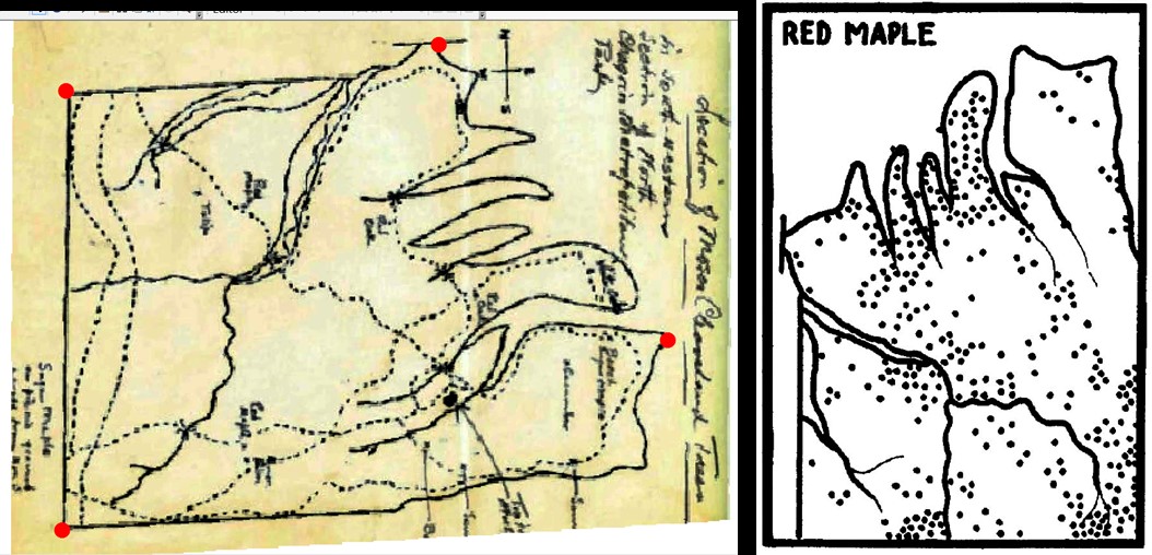
After we learned the basic functionality, we began to translate our photographs into architectural models in Sketchup. The program allows the user to upload an image and transform the two-dimensions represented within it into three dimensions of digital space. It does this by insinuating axis lines on the image, and “pushing” the façade of the building back into a third dimension, as demonstrated in these two photos:

Figure 1. Screenshot of a building in Sketchup showing how 2D images are projected into 3D space.
 
Figure 2. Screenshot of a building in Sketchup showing early stages of 3D modeling from a 2D photo of a building.
 

Because this process involves transforming a two-dimensional image into three-dimensional space, it is imperative to start with the right kind of image. The one used above demonstrates the proper perspective; essentially, the image must contain a vanishing point. Head-on images do not allow the user to determine how deep the actual physical building is and are therefore not usable in this process.

Next, the user can begin to add features to their model, referring back to the two-dimensional image as necessary. In our class, we allowed students two additional weeks to complete this process. We found this to be necessary since none of our students were previously familiar with Sketchup. This time therefore allowed them to troubleshoot errors as they came up. Class time was dedicated to working on our models together. Students and instructors collaborated with one another and shared strategies and tips. Finally, the completed models were rendered with V-Ray, a plugin for Sketchup which places the models in simulated environments, adding convincing lighting and other scenery effects.

Many projects succeeded. Graham McGrew, for example, started with an unbuilt plan from the 1960s for an A-frame building to house the university’s seminary chapel, as shown in this final rendered image:

Figure 3. Final rendering of un-built “A”-frame chapel made by Graham McGrew.
 

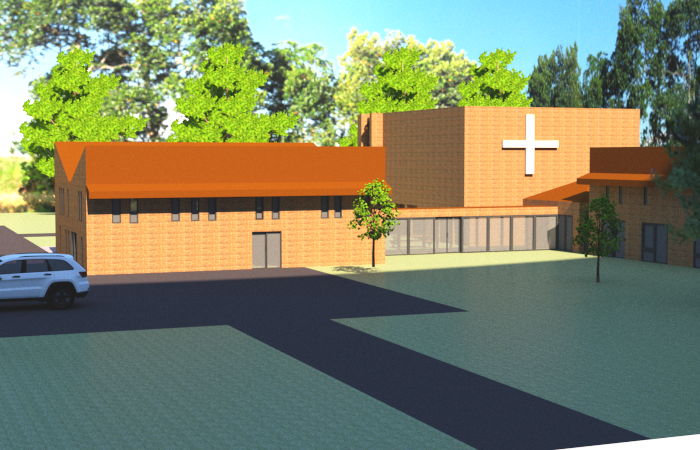
Another student, Bobbie Jo Chapkin, chose to model the existing Seminary building, as shown in this final rendered image:

Figure 4. Final rendering of 3D model of Bethel Seminary.
 

There are clear challenges to incorporating archival practices into digital humanities pedagogy. Regarding our lesson here, students lacking familiarity with video games or other three-dimensional computing tools may find orienting themselves to Sketchup challenging. And, as with any large project, the quality of the final products will depend entirely on the effort and energy students put in. Still, this project successfully combined a focus on the humanistic value of the archive with a modern software application to create a sophisticated experience that recreated an episode from our past campus.

Expanding from this specific project to consider the collaborative efforts described here generally, the intersection between three diverse academic disciplines might be thought to be a difficult place for three busy researchers and teachers to land upon. However, we feel that the best strategy for effecting meaningful interdisciplinary pedagogy in the archive and the humanities is to encourage organic opportunities to develop at their own pace, and to scaffold larger projects such as this one upon the foundations already laid. Our efforts were long in the making—Bethel’s archivist position was created in 1998, its digital librarian position in 2009, and its Digital Humanities position in 2016. Rome, even as a modern HBO set, wasn’t built in a day. Though incorporating the traditional archive into digital undergraduate pedagogy is a relatively recent effort, it still rests primarily on tried-and-true humanities principles like thoughtful reading, analysis, and attention to detail.

Bibliography

Alexander, Bryan and Rebecca Frost Davis. 2012. “Should Liberal Arts Campuses do Digital Humanities? Process and Products in the Small College World.” In Debates in the Digital Humanities, edited by Matthew K. Gold. Minneapolis: University of Minnesota Press.

Association of College and Research Libraries. 2015. “Framework for Information Literacy for Higher Education.” American Library Association, Association of College and Research Libraries Division. February 2, 2015. Accessed October 29, 2018. http://www.ala.org/acrl/standards/ilframework.

Battershill, Claire and Shawna Ross. 2017. Using Digital Humanities in the Classroom: A Practical Introduction for Teachers, Lecturers, and Students. London; New York: Bloomsbury Academic.

Brier, Stephen. 2012. “Where’s the Pedagogy? the Role of Teaching and Learning in the Digital Humanities.” In Debates in the Digital Humanities, edited by Matthew K. Gold. Minneapolis: University of Minnesota Press.

Bryn Mawr College. n.d. “What Are Digital Competencies?” Accessed October 29, 2018. https://www.brynmawr.edu/digitalcompetencies/what-are-digital-competencies.

Burdick, Anne, Johanna Drucker, Peter Lunenfeld, Todd Presner, and Jeffrey Schnapp. 2012. Digital_Humanities. Cambridge, MA: MIT.

Buurma, Rachel Sagner and Anna Tione Levine. 2016. “The Sympathetic Research Imagination: Digital Humanities and the Liberal Arts.” In Debates in the Digital Humanities, edited by Matthew K. Gold. Minneapolis: University of Minnesota Press.

Christian-Lamb, Caitlin and Anelise Hanson Shrout. 2017. “‘Starting from Scratch’? Workshopping New Directions in Undergraduate Digital Humanities.” Digital Humanities Quarterly 11 (3). http://www.digitalhumanities.org/dhq/vol/11/3/000311/000311.html.

Cordell, Ryan. 2016. “How Not to Teach Digital Humanities.” In Debates in the Digital Humanities, edited by Matthew K. Gold. Minneapolis: University of Minnesota Press.

Gerber, Kent. 2017. “Conversation as a Model to Build the Relationship among Libraries, Digital Humanities, and Campus Leadership.” College & Undergraduate Libraries 24 (2–4): 418–433. https://doi.org/10.1080/10691316.2017.1328296.

Goode, Kimberly. 2017. “Blending Photography and the Diorama: Virtual Reality as the Future of the Archive & the Role of the Digital Humanities.” MediaCommons Field Guide: “What is the Role of the Digital Humanities in the Future of the Archive.” May 4, 2017. Accessed October 25, 2018. http://mediacommons.org/fieldguide/question/what-role-digital-humanities-future-archive/response/blending-photography-and-diorama-virtu.

Jewell, Kaelin. 2017. “Digital Tools and the Pedagogy of Early Medieval Visual Culture.” Peregrinations: Journal of Medieval Art and Architecture 6 (2): 30–39.

Karukstis, Kerry K. and Timothy E. Elgren. 2007. Developing and Sustaining a Research-Supportive Curriculum : A Compendium of Successful Practices, edited by Kerry K. Karukstis, Timothy E. Elgren. Washington, DC: Council on Undergraduate Research.

Locke, Brandon T. 2017. “Digital Humanities Pedagogy as Essential Liberal Education: A Framework for Curriculum Development.” Digital Humanities Quarterly 11 (3). http://www.digitalhumanities.org/dhq/vol/11/3/000303/000303.html.

Mackey, Thomas P. and Trudi E. Jacobson. 2014. Metaliteracy: Reinventing Information Literacy to Empower Learners, edited by Trudi E. Jacobson. Chicago: ALA Neal-Schuman.

Mattern, Shannon. June 2014. “Library as Infrastructure.” Places Journal. https://doi.org/10.22269/140609.

Middleton, Ken and Amy York. 2014. “Collaborative Publishing in Digital History.” OCLC Systems & Services: International Digital Library Perspectives 30 (3): 192-202. https://doi.org/10.1108/OCLC-02-2014-0010.

Murphy, Emily Christina and Shannon R. Smith. 2017. “Introduction.” Digital Humanities Quarterly 11 (3).
http://www.digitalhumanities.org/dhq/vol/11/3/000334/000334.html.

Olson, A. 1952. A Centenary History: As Related to the Baptist General Conference of America. Chicago: Baptist General Conference Press.

Rutner, Jennifer and Roger C. Schonfeld. 2012. Supporting the Changing Research Practices of Historians. Ithaka S+R Report.

Sayers Jentery. 2011. “Tinker-Centric Pedagogy in Literature and Language Classrooms.” In Collaborative Approaches to the Digital in English Studies, edited by Laura McGrath. Computers and Composition Digital Press. https://ccdigitalpress.org/book/cad/Ch10_Sayers.pdf.

Svensson, Patrik. 2010. “The Landscape of Digital Humanities.” Digital Humanities Quarterly 4 (1). http://digitalhumanities.org/dhq/vol/4/1/000080/000080.html

Svensson, Patrik. 2011. “From Optical Fiber to Conceptual Cyberinfrastructure.” Digital Humanities Quarterly 5 (1). http://digitalhumanities.org/dhq/vol/5/1/000090/000090.html.

Vandegrift, Micah and Stewart Varner. 2013. “Evolving in Common: Creating Mutually Supportive Relationships between Libraries and the Digital Humanities.” Journal of Library Administration 53 (1): 67–78.

White, Krista. 2017. “Visualizing Oral Histories: A Lab Model using Multimedia DH to Incorporate ACRL Framework Standards into Liberal Arts Education.” College & Undergraduate Libraries 24 (2-4): 393–417.
https://doi.org/10.1080/10691316.2017.1325722.

Wosh, Peter J., Cathy Moran Hajo, and Esther Katz. 2012. “Teaching Digital Skills in an Archives and Public History Curriculum.” In Digital Humanities Pedagogy: Practices, Principles and Politics, edited by Brett D. Hirsch. 79–96. Cambridge: Open Book Publishers. http://books.openedition.org/obp/1620.

Appendix – Technology Tools

Spreadsheets (Google Sheets, Excel)
CONTENTdm
Epson Expression XL 10000 Flatbed Scanner
Sketchup
V-Ray plugin for Sketchup

About the Authors

Kent Gerber, the Digital Library Manager at Bethel University, is responsible for the library’s digital collections, the Makerspace, and collaborative digital scholarship projects. He holds an MLIS and Certificate of Advanced Studies in Digital Libraries from Syracuse University and focuses on how libraries engage with technology, teaching, research, cultural heritage, and digital humanities through facilitating conversation. He serves on the Operations Committee for the Minnesota Digital Library and co-designed new Bethel programs including the Digital Humanities major and the Makerspace.

Charlie Goldberg is Assistant Professor of History and Digital Humanities Coordinator at Bethel University. He helped design and currently oversees Bethel’s undergraduate Digital Humanities major. He has a Ph.D. from Syracuse University, and his primary research pertains to gender and politics in ancient Greece and Rome.

Diana L. Magnuson is Professor of History at Bethel University and Director of Archives, History Center of Bethel University and Converge. She holds a Ph.D. from the University of Minnesota and teaches courses on American history, introduction to history, and geography. As Director of Archives, Magnuson stewards and provides access to manuscripts, media, three-dimensional objects, and digital materials that document the institutional history of Bethel University and Converge. Magnuson also curates the institutional history of the Minnesota Population Center at the University of Minnesota, Twin Cities Campus.

Hand of a student examining documents in Cleveland Museum of Natural History Archives.
1

Branching Out: Using Historical Records to Connect with the Environment

Abstract

What started out as an effort to digitize a small collection (two and a half linear feet) of archival material mushroomed into several interconnected projects, described here, that demonstrate the value of accessibility of historical records in the natural sciences. Funding from the National Historical Publications and Records Commission enabled the Cleveland Museum of Natural History to collaborate with Baldwin Wallace University to create an accessible online repository of original material from Cleveland naturalist A.B. Williams, and to design a curriculum for teaching with those primary sources in middle and high school classrooms. Graduate students at the University of Akron were instrumental in developing lesson plans, field trip protocols, and even a unique game from the digitized resources to facilitate learning about the different types of trees in the A.B. Williams Memorial Woods. Further collaborations followed, creating opportunities for undergraduate students at two area universities (University of Akron and Baldwin Wallace) to use the digitized data within the historical records to create georeferenced maps and to conduct a re-survey of the forest. This paper highlights how the digitization of archival materials allows for the development of numerous types of educational and research resources, with three products as proofs of concept.

Introduction: Teaching with Historical Records in the Natural Sciences

In the sciences, primary sources can be defined as records of observations in the natural world. Teaching with primary sources is an integral part of inquiry-based learning, and both archivists and educators have embraced opportunities to use archival materials in the classroom. Allowing students to use the raw material of scholarship has the potential to reap benefits. Students learn to consider different perspectives and to think critically (Hendry 2007). Students might also feel more invested in their research when they get to see original sources (Tally and Goldenberg 2005). By working with primary sources in the sciences, students can develop their own skills of observation and analysis (Austin and Thompson 2015). The Discover – Explore – Connect project was developed to introduce middle and high school students to different types of historical records in the natural sciences, such as field notes, maps, and photographs. By engaging with these primary sources, the project aims to teach and enforce the skills of observation and analysis in both the classroom and outdoors. The project demonstrates how both educational and research tools can be developed and implemented when archival materials are made accessible through digitization.
In July 2016, the Archives of the Cleveland Museum of Natural History (CMNH) received a two-year grant from the National Historical Publications and Records Commission (NHPRC). The project, titled Discover – Explore – Connect: Engaging with the Environment through Historical Records in the Natural Sciences, was part of the NHPRC’s Literacy and Engagement with Historical Records program. The funding allowed the CMNH Archives to digitize 2.5 linear feet of records relating to Arthur B. Williams, a naturalist and educator who shaped outdoor education in the Cleveland area in the 1930’s – 1950’s. Digitization not only allows access to the irreplaceable primary sources, but does so in a way that allows preservation of the original documents and materials. The material was digitized by work-study students at Baldwin Wallace University, under the supervision of the University Archivist. The students who digitized the material learned how to handle fragile documents, use scanning equipment, and assign metadata to the finished electronic documents.

With the rich resources within the A.B. Williams archive digitized, teachers, students, researchers, and citizen scientists can access and use the material to glean valuable information about the natural world around them. Several interconnected projects have been developed that draw from the A.B. Williams Archive: a curriculum that contains both classroom and outdoor experiences, including a game; GIS applications; and a re-survey of the forest that allows for comparison with the historical data.

Results: Projects Derived from Digitized Materials

Lesson plans for ecological literacy

The goal of the Discover – Explore – Connect curriculum is to teach middle school and high school students the skills necessary to study the natural world around them. Through a series of lessons, students learn orienteering, species identification, mapping, taking field notes, and collecting data, with A.B. Williams as their guide. The curriculum is divided into three major sections: Skills Development and Game-Based Learning; Field Trip to A.B. Williams Memorial Woods; and the Land Ethic.

The lesson plans in the Skills Development section introduce students to primary sources and teach them how to identify and analyze different types of primary sources, such as maps, photographs, and written documents. Students also learn how to interpret and use different types of information that can be found in scientific documents, such as charts, data tables, maps, graphs, and diagrams. Additional lesson plans guide students in making observations, keeping field notes, finding their way around a map, and recording observations on a map. Subsequent lessons help students build skills in identifying different species of wildflowers, birds, and trees.

A unique addition to the curriculum is a game that was developed as an orientation for field trips to the A.B. Williams Memorial Woods in the North Chagrin Reservation of the Cleveland Metroparks. Well-designed games have been shown to facilitate engagement with learning (Dickey 2005; Abdul Jabbar and Felicia 2015) and improve meaning-making for the players (Ermi and Mayra 2005). The game was designed to deliver three main learning outcomes: familiarize students with the layout of the A.B. Williams Memorial Woods; provide a practical tutorial in using dichotomous keys to identify wildlife; and prepare students to survey plant and animals communities in the forest. By simulating the types of activities that will take place on their visit to the forest, students should be better prepared and focused during the field trip (Falk and Dierking 2000).

For the game’s design and construction, the A.B. Williams Memorial Woods was split into five regions based on different forest communities: Beech-Maple Association; Northwest Forest; Southeast Forest; Spurs and Ravines; and Swamp Forest (Figure 1).

A map of the A.B. Williams Memorial Woods. It is divided into five color-coded regions: Northwest Forest; Spurs and Ravines; Southeast Forest; Beech-Maple Association; Swamp Forest.

Figure 1. Game map showing the different regions of the A.B. Williams Memorial Woods in the North Chagrin Reservation of the Cleveland Metroparks

Using A.B. Williams’ historical survey data of tree distributions, decks of cards were constructed for each of these regions. Each deck contains between 17 and 39 cards. Individual tree species for each region are depicted on the cards using illustrations of leaves that were drawn by A.B. Williams and are part of the digitized collection; drawings of twigs and buds were created by the project’s graphic designer to provide additional information to aid species identification. Each card provides enough information for the tree species to be identified using the provided dichotomous key or a field guide, along with a symbol to allow for easy sorting of cards based on region, and a number value to indicate how many individual trees that card represents (Figure 2).

An example of card used in the tree identification game. It depicts the leaf and stem pattern, the forest community in which it is found, and the number of individual trees the card represents.

Figure 2. Example of card showing a single species of tree to be identified

For each deck, the number of cards depicting the same tree species is based upon the proportionate number of those trees surveyed in that region by Williams in the 1930’s (Williams 1936). To keep the decks at workable sizes while allowing for representation in the deck of all the tree species in each region, the ratio of number of cards to total count of corresponding tree species is arranged upon a log scale, which results in the number of cards per species corresponding roughly with order of magnitude rather than actual counts. Accompanying these decks are a specially constructed dichotomous key (Figure 3) and data collection sheets for student groups to record distribution data (multiple cards of the same species have different numbers to simulate the actual counting activity). Instructors also have an answer and scoring sheet that allows them to track student success rates and completion times, and to check on each group’s work.

A dichotomous key for the trees found in the A.B. Williams Memorial Woods. It features 17 questions about a tree’s characteristics, each with two answers. Each answer leads to another question, which then points to the tree’s identity by the end of the questions.

Figure 3. Dichotomous key to be used for identifying trees in the A.B. Williams Memorial Woods

Gameplay requires students to work together in teams to effectively and efficiently identify the trees in each region. The game can be played while sitting at a desk, but we encourage teachers to set up the classroom as the forest and have students move around from community to community. The instructor serves as a scorekeeper to track both accuracy and speed, and each student group competes to be best at identifying and surveying tree species. As players progress through surveying each region’s deck, they will grow more proficient in using the dichotomous key to identify trees, and they will acquire information on the distributions of individual tree species throughout the A.B. Williams Memorial Woods.

Future work can not only further develop this game, but also expand upon it to include modules that examine wildflowers and songbirds, using resources made available through the digitized A.B. Williams archival material. This game is designed in such a way that it can easily be adapted to any location that has robust biological survey data, with limited adjustment to its design. The game is currently being developed to work as a standalone boxed experience that can be played like a traditional board/card game as opposed to a classroom activity.

The Discover – Explore – Connect curriculum was introduced at a teacher workshop held at CMNH in February 2018. The 18 teachers who attended the workshop included classroom teachers, homeschool parents, university/college educators, and informal science educators (i.e., museum docents, library media specialists, park naturalists). Educators worked through several lessons and played a test version of the A.B. Williams Forest Community Challenge Game. We received valuable feedback on the game and the curriculum, and this input will help as we continue to develop both for future use.

Following the workshop, we tested the curriculum and field trip with five classes of 10th-grade biology students from a school within the Cleveland Metropolitan School District. The teacher had attended the workshop in February and, because her school has an extended academic year, she was able to work through some of the lesson plans and schedule a field trip. Project team members visited the school at the end of May and introduced the A.B. Williams Forest Community Challenge Game to each of the five biology classes during the school day. Fifty students learned how to use the dichotomous key to identify trees featured on the game cards. While challenging at first, by the end of each class we could see that the students had made a lot of progress. The game set the stage for the June 22nd field trip to the A.B. Williams Memorial Woods. Team members planned a full day of field experiences at four different stations in the woods. The 27 students in attendance, accompanied by their teacher and three chaperones, were broken up into four groups. Each group was led by a member of the project team as they cycled through all four stations and completed the activities, which included counting and measuring trees within a designated area, honing observation skills while focusing on sounds, and learning about the Civilian Conservation Corps’ efforts to build a shelter in the woods in 1933.

The field trip was a rewarding experience for everyone. While guiding a group into the forest, the leader held up a large leaf that had been found on the ground. One of the students immediately noticed its shape and started to identify it based on the dichotomous key used during the A.B. Williams Forest Community Challenge game in class. Following the field trip, the teacher solicited feedback from her students. One of the students said, “The field trip was very breathtaking…A.B. Williams – I feel like I was walking on his path [and] you saw his nature as it was…I feel like what he did was awesome.”

Our hope is that the Discover – Explore – Connect curriculum will be used in classrooms throughout the school year, so that by April or May teachers and students will be ready for at least one field trip to the A.B. Williams Memorial Woods. Lesson plans for the field trip include mapping and tallying trees and comparing those numbers with what Williams observed in those same woods 80 years ago. Once back in the classrooms, students turn to lesson plans that help them reflect on the changes that have occurred in the forest ecosystem and encourage them to examine their relationship with the natural world around them.

Where in the world…? Applying GIS technologies to historical records

The digitization of the Williams collection not only provides access to more easily view the materials, but an exciting further step is to integrate the historical maps using Geographic Information Systems (GIS). GIS is database software that allows disparate data sources to be integrated and assigned to specific coordinates on a map. This process requires that features in the maps be identified and related to a spatial reference system. The term ‘georeferencing’ is used to describe this process of adding a spatial reference system to the digital image of a historical map.

Along with visually comparing maps that have been georeferenced to the same spatial reference system, the features on the map can be depicted using points, lines, and areas. These point, line, and area features can then be graphically manipulated, incorporated with other spatial data sets, and quantitatively analyzed. For example, Williams made many maps of the trees in the North Chagrin Reservation of the Cleveland Metroparks; when georeferenced, the trees drawn on these maps can be converted to points, combined with trees from other maps, and drawn in any cartographic style.

Georeferencing the hand-drawn maps from Williams was both challenging and critical to the accuracy of any derived spatial data sets. Whatever spatial uncertainty is present in the georeferencing (there was considerable uncertainty) will be propagated through any future uses of the maps. The general strategy in georeferencing is to find features on the map that can either be located on other spatial data sets, such as aerial photography or topographic maps, or can be located in the current landscape. Whether on other imagery or in the current landscape, these identifiable locations used for georeferencing the historical maps are known as ground control points or GCPs.

Because Williams included different features on different maps but did not ever include all the features on a single map, the necessary strategy was to georeference his maps by using the best ground control points from each map. For instance, features on Williams’ maps that could not move over time, such as the foundation of the Trailside Museum in the North Chagrin Reservation, provided the best way to match features on the historical map to current features in the landscape whose coordinates we can measure with global positions systems (GPS). Because there were not enough of these more permanent features, other features such as bridges and trail intersections were also used. Since these features have a higher likelihood of having moved over the past eight decades, they introduce more uncertainty into the georeferencing process. Three authors of the paper went out into field in September of 2017 to obtain the GPS coordinates of locations/objects that were present on A.B. Williams’ various maps and could potentially be used as ground control points (Figure 4).

The image shows GIS software where a map drawn by A. B. Williams is being georeferenced using coordinates of features that are still currently visible in the landscape. These features include trails, bridges, buildings, and select trees.

Figure 4. A screenshot showing one of A.B. Williams’ hand-drawn maps matched to GPS coordinates of GCPs. The table on the top right of the image shows details on the GCPs such as latitude and longitude, as well as root mean square error (RMS).

In several GIS and Cartography courses, undergraduate and graduate students were provided with digital versions of some of Williams’ maps of trees by species and ground control points generated by the instructors. Since Williams produced no single map that contained all the features that could serve as GCPs, the students were instructed to utilize a series of exterior points on the species maps derived from the original georeferencing attempt (Figure 5).

The image shows two maps. The first map shows features, such as trails and bridges that were used as ground control points when visited by course instructors. The second map is an example of a map of individual species that students georeferenced. Coordinates for easily identifiable locations were extracted from the first map to allow students to more easily and accurately georeference the second map.

Figure 5. GPS coordinates were used by instructors to georeference an A.B. Williams map (left map above) and then four clearly identifiable locations were chosen for students to use to georeference maps of individual species such as the map of red maple.

The students then georeferenced their assigned species maps and created point representations of the individual trees. This assignment covered several core GIS methods, including georeferencing, feature creation, editing attribute tables, and spatial reference system concepts, while engaging students in the creation of new geospatial data that will be used in future coursework, research, and public displays. The use of historical data also allowed an important discussion of the value of archives in change analysis and the sources and implications of uncertainty in spatial data.

The spatial data sets of tree locations created by the students in the GIS and Cartography courses were then analyzed by students in a Spatial Analysis course. The students in this course were learning to use spatial statistical methods to identify and describe spatial patterns in large data sets. The data set of tree locations created in the earlier exercise included the species of the tree, so interspecific comparisons of clustering and dispersion were done by the students using common spatial statistics, such as average nearest neighbor, quadrat analysis, and Ripley’s K function. Several of the students in the Spatial Analysis course were also in the GIS or Cartography courses, and they were able to help explain the larger story of Williams’ work to the students who had not previously been exposed to the archive. Anecdotally, student reflections suggest that the use of historical hand-drawn maps makes the presence of spatial uncertainty more obvious than with modern digital data sources. Students were able to translate the uncertainty introduced from the data source into reasonable limitations in the interpretation of results.

While the maps that are part of the Williams archive have already proven to be pedagogically valuable, we expect to continue to develop these data sources in several ways. There are still numerous maps that need to be georeferenced and have their contents converted to spatial features. Our initial experiences in this process have been positive and instructive. As more of the maps are processed, the database available for spatial analysis will also grow. This database will be utilized by students in course assignments and individual projects. As more of the maps and spatial data are completed, students in the GIS Database Design course will be learning ways to make these databases publicly available through web mapping applications.

Once the maps have been processed and converted to features, they can be compared with the results of the re-survey efforts described in the next section of the paper. This increases the value of the data from analyzing the past to investigating how the present-day forests have changed. We expect that this highly detailed spatial database of plants and animal locations over an 80-year period in a highly urbanized and industrialized region will be valuable both for research and for communicating ecological change to the broader community.

Seeing the forest through the trees

Scientific researchers are also using the A.B. Williams archive to assess changes that have occurred over 86 years in the tree community diversity, composition, and structure of the old-growth A.B. Williams Memorial Woods. Undergraduate students, along with their professor, replicated Williams’ methods to resample trees in 58 of his plots. Such re-survey studies are valuable to the field of ecology because they provide the only direct evidence of changes over time in local species diversity and abundance (Sax and Gaines 2003; Kapfer et al. 2017). Other recent studies have used legacy data to gain insights into long-term ecological processes (Vellend et al. 2013; Perring et al. 2018), but few have been long enough to see changes in tree populations and forest communities (Müllerová et al. 2015; Šebesta et al. 2011). The Williams data provides a unique opportunity to observe changes over time in a protected old-growth forest.

In 1932, Williams (1932, 1936) counted, identified, and measured all trees ≥ 0.8-cm diameter in 44 8 × 10-m plots; counted and identified all trees at least knee high in 10 30 × 30-m plots; and counted, identified, and measured all trees at least 2 m tall in 4 15 × 15-m plots. In 2018, we relocated these plots based on the georeferencing described in the previous section and using Williams’s original tree maps, which enabled us to locate remaining individual trees. We counted, identified, and measured trees according to Williams’ methods. We plan to compare stand structure between 1932 and 2018, including stem density, basal area, and the proportions of stems in different size classes. We will compare species richness, diversity, and composition using techniques such as ordination and indicator species analysis. Finally, the observed changes will allow us to examine hypotheses about which factors, such as increased deer density or tree diseases, have driven the development of this forest. We can also assess whether tree species with certain traits have tended to increase in frequency. This study will provide rare insight into how and how much a protected old-growth forest changes over time in diversity, composition, and structure, and will suggest which ecological factors are responsible for the changes. The project provides information useful to basic ecological theory and to applied ecosystem management, including the managers of A.B. Williams Memorial Woods at Cleveland Metroparks, while providing opportunities to mentor undergraduate students in research.

Conclusion

Observations by local naturalists over a long period of time can shed light on seasonal changes. By comparing the data in these historical records with current observations and digitally captured data, scientists can investigate a number of phenomena including the impacts of climate change (Primack and Miller-Rushing 2012; Primack 2014; Ledneva et al 2004). Mining the data contained in historical scientific records has become easier than ever thanks to recent digitization efforts, such as the Smithsonian Field Book Project and Biodiversity Heritage Library, but many sources of historical observations remain hidden and unused in various repositories.

The Discover – Explore – Connect project had many moving parts with three main goals: digitize and make accessible this collection of archival material, create a curriculum for middle and high school teachers, and hold training for educators to learn how to teach using these primary sources in their classrooms and outdoors. From these goals, the project expanded its scope to include other uses for the valuable data contained within the digitized material, including a game, georeferenced maps, and a re-survey of a local forest. Two and a half linear feet of historical records can be developed and used in several different and exciting ways.

Bibliography

Abdul Jabbar, Azita Iliya, and Patrick Felicia. 2015. “Gameplay Engagement and Learning in Game-Based Learning: A Systematic Review.” Review of Educational Research 85(4): 740–779.

Austin, Hilary Mac, and Kathleen Thompson. 2015. Examining the Evidence: Seven Strategies for Teaching with Primary Source. Chicago: Maupin House Publishing.

Dickey Michele. 2005. “Engaging by Design: How Engagement Strategies in Popular Computer and Video Games Can Transform Instructional Design.” ETR&D 53(2): 67–83.

Ermi, Laura, and Frans Mäyrä. 2005. “Fundamental Components of the Gameplay Experience: Analysing Immersion.” In Proceedings of the 2005 DiGRA International Conference: Changing Views: Worlds in Play, 15–27. http://www.digra.org/wp-content/uploads/digital-library/06276.4156.pdf.

Falk, J. H., & Dierking, L. D. 2000. Learning from Museums: Visitor Experiences and the Making of Meaning. Lanham, MD: Rowman & Littlefield.

Hendry, Julia. 2007. “Primary Sources in K-12 Education: Opportunities for Archives.” American Archivist 70 (Spring/Summer): 114-29.

Kapfer, Jutta, Radim Hédl, Gerald Jurasinski, Martin Kopecky, Fride H. Schei, and John-Arvid Grytnes. 2017. “Resurveying Historical Vegetation Data—Opportunities and Challenges.” Applied Vegetation Science 20 (2): 164-171.

Ledneva, Anna, et al. 2004. “Climate Change as Reflected in a Naturalist’s Diary, Middleborough, Massachusetts.” Wilson Bulletin 116, no. 3: 224-231.

Müllerová, Jana, Radim Hédl, and Péter Szabó. 2015. “Coppice Abandonment and its Implications for Species Diversity in Forest Vegetation.”Forest Ecology and Management 343: 88-100.

Perring, Michael P., Markus Bernhardt-Römermann, Lander Baeten, Gabriele Midolo, Haben Blondeel, Leen Depauw, Dries Landuyt, et al. 2018. “Global Environmental Change Effects on Plant Community Composition Trajectories Depend upon Management Legacies.” Global Change Biology 24 (4): 1722-1740.

Primack, Richard B., and Abraham J. Miller-Rushing. 2012. “Uncovering, Collecting, and Analyzing Records to Investigate the Ecological Impacts of Climate Change: a Template from Thoreau’s Concord.” BioScience 62 (February): 170-81.

Primack, Richard B. 2014. Walden Warming: Climate Change Comes to Thoreau’s Woods. Chicago: University of Chicago Press.

Sax, Dov F. and Steven D. Gaines. 2003. “Species Diversity: From Global Decreases to Local Increases.” Trends in Ecology and Evolution 18 (11): 561-566.

Šebesta, Jan, Pavel Šamonil, Jan Lacina, Filip Oulehle, Jakub Houška, and Antonín Buček. 2011. “Acidification of Primeval Forests in the Ukraine Carpathians: Vegetation and Soil Changes over Six Decades.” Forest Ecology and Management 262 (7): 1265-1279.

Tally, Bill, and Lauren B. Goldenberg. 2005. “Fostering Historical Thinking with Digitized Primary Sources.” Journal of Research on Technology in Education 38 (1): 1-21.

Vellend, Mark, Lander Baeten, Isla H. Myers-Smith, Sarah C. Elmendorf, Robin Beauséjour, Carissa D. Brown, Pieter De Frenne, Kris Verheyen, and Sonja Wipf. 2013. “Global Meta-Analysis Reveals No Net Change in Local-Scale Plant Biodiversity over Time.” Proceedings of the National Academy of Sciences 110 (48): 19456-19459.

Williams, Arthur B. 1932. “A Preliminary Study of a Beech-Maple Climax Community.” PhD diss., Case Western Reserve University, Cleveland, Ohio.

Williams, Arthur B. 1936. “The Composition and Dynamics of a Beech-Maple Climax Community.” Ecological Monographs 6: 317-408.

Appendix: Methods

Future usability of the digitized material was maximized through the methods of processing.

  • All scans were saved as non-compressed, lossless TIFFs at 600 dpi and then stitched together to create multi-page PDFs, to allow both maximum resolution and perusal.
  • Digitizers at BW used an ATIZ BookDrive DIY cradling book scanner, complete with two mounted Canon Rebel T2i 18.0 MP digital cameras and proprietary software.
  • Individual documents were scanned on an Epson Perfection V33 flatbed scanner, and an ELMO TT-12i overhead document camera was used to digitize the most fragile documents, such as a scrapbook of cyanotype photograms from 1910-1915.
  • Once digitized and converted to PDFs, all applicable text was OCRed via Adobe Acrobat Pro DC and then uploaded to an online collection hosted by BW using OCLC CONTENTdm. Metadata was assigned using Library of Congress Authorities.

About the Authors

Thomas R. Beatman is an Integrated Biosciences Ph.D. candidate in the Biology Department at the University of Akron. His dissertation is on the theory and application of using games and gameful experiences. He uses his background in biology in the design and development of science communication toolkits to translate complex biological problems to be more understandable to the public. His primary interest is in communicating biodiversity and evolution in informal science education environments.
Shanon Donnelly is an Assistant Professor in the Department of Geosciences at the University of Akron, where he uses geospatial technologies in teaching and research. He employs tools such as geographic information systems and remote sensing in the pursuit of connecting people’s lived experiences with emergent patterns of impact and opportunity across spatial and temporal scales.
Kathryn M. Flinn is an ecologist and Associate Professor of Biology at Baldwin Wallace University in Berea, Ohio. She earned a Ph.D. in Ecology and Evolutionary Biology from Cornell University. Her recent research examines plant community change through time in northeast Ohio. With two undergraduate collaborators, she assessed changes in an old-growth forest over 86 years by resurveying A.B. Williams’s plots. The results are forthcoming in Journal of the Torrey Botanical Society.
Jeremy M. Spencer is an Assistant Professor of Instruction in the Department of Geosciences at the University of Akron. He received his Ph.D. in climatology from Kent State University, where he focused on the impact of cold weather on human mortality. Currently, his academic interests involve the communication of climatology and geography. This includes outreach to local elementary and middle schools, as well as developing course materials that promote inquiry and critical thinking in college geography and atmospheric science courses.
Ryan J. Trimbath is an Ecologist and Natural Resource Manager with broad interest in understanding and protecting nature. He received a B.S. in Wildlife and Conservation Biology from Ohio University and is a Ph.D. candidate in Biology at the University of Akron. Ryan feels lucky to have opportunities to study forests across the country from Hawaii to New Hampshire.
Wendy Wasman is the Librarian & Archivist at the Cleveland Museum of Natural History in Cleveland, Ohio, where she oversees the 50,000-volume research library, curates the rare book collection, and manages the archives and special collections. She earned a B.A. from Oberlin College and an M.L.S. from Kent State University.


jitp

Skip to toolbar